Courtesy of NOAA.gov
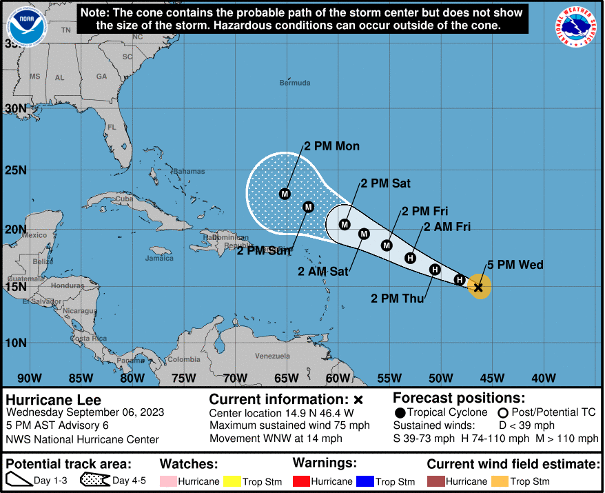
Tropical Storm Lee became a hurricane Wednesday afternoon, according to the latest update from the National Hurricane Center, and is expected to become an “extremely dangerous hurricane.”
Lee’s maximum sustained winds were near 75 mph with higher gusts at 5 p.m. Wednesday, and it was moving steadily west-northwest toward the Caribbean.
The National Hurricane Center said Lee was expected to become a major hurricane by Saturday. Swells generated by the storm are expected to reach the Lesser Antilles, in the Caribbean Sea, on Friday, with life-threatening surf and rip currents. They will reach the British and U.S. Virgin Islands and Puerto Rico this weekend.
The storm is currently forecast to skirt north of most islands in the Caribbean, and will potentially make a harder turn north, toward Bermuda, early next week.
If Lee spends the coming days over open water, which rose to record high surface temperatures this season, it could potentially become a Category 4 storm, forecasters said.
Although the forecast track could change, Lee isn’t expected to directly impact the U.S. Southeastern states are still recovering from Hurricane Idalia, which made landfall Aug. 30 on the Gulf Coast of Florida as a powerful Category 3 storm before cutting across Georgia and the Carolinas.
Even if Lee passes by the southeastern U.S., it could still produce dangerous swells and rip currents along the East Coast, forecasters said.
TMX contributed to this article.