Courtesy of nwsnhc_hurricanes/Instagram
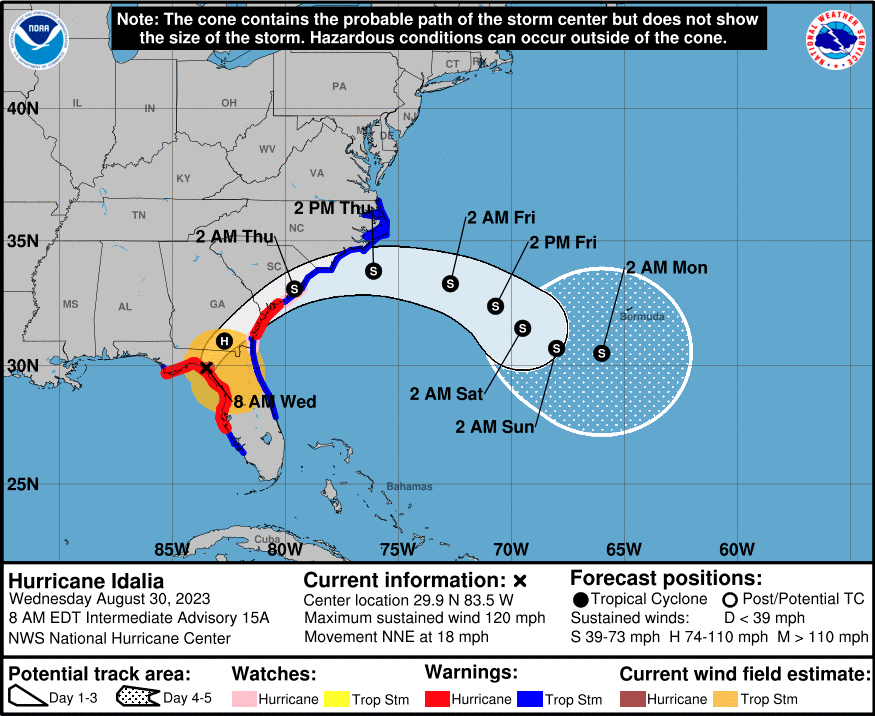
Hurricane Idalia made landfall near Keaton Beach, Fla., at 7:45 a.m. Wednesday, as a Category 3 storm, with the National Hurricane Center warning of catastrophic storm surge and extreme winds in the state’s Big Bend region, where the peninsula meets the panhandle on the Gulf Coast.
At 5 a.m. Wednesday, Idalia was a Category 4 storm with maximum sustained winds of 130 mph and higher gusts ahead of landfall. In a 7 a.m. update, maximum sustained wind speeds had dropped slightly to 125 mph, but the agency warned the fluctuation “does not diminish the threat of catastrophic storm surge and damaging winds.”
A storm surge warning and hurricane warning were in effect from Englewood in South Florida north to Indian Pass, in the panhandle southwest of Tallahassee. Extreme wind warnings were in effect in the forecast area of the National Weather Service office in Tallahassee, and multiple tornado warnings were issued early Wednesday by NWS Tampa.
The National Hurricane Center warned early Wednesday of storm surge inundation of 12–16 feet above ground level in the Big Bend region, and life-threatening storm surges along much of the rest of the state’s Gulf Coast.
The agency warned of destructive, life-threatening winds as Idalia’s core makes landfall in the Big Bend, with strong winds spreading inland and into southern Georgia.
Rain totals of up to 12 inches are possible through Thursday near landfall in northern Florida, with 4–8 inches likely across other parts of Florida, southeastern Georgia and the eastern Carolinas, according to the National Hurricane Center.
On Wednesday morning, storm surge was already rising rapidly at Cedar Key, west of Ocala, despite it being low tide, according to NWS Tallahassee.
Gov. Ron DeSantis on Saturday declared a state of emergency across 33 counties ahead of the storm. Evacuations began Monday in multiple zones, with shelter-in-place orders issued in coastal regions early Wednesday.
TMX contributed to this article.